Satellite Science · 35-Year Analysis · Landsat-5 + Sentinel-2
What the satellites found
We did not ask volunteers what happened to Baner Hill. We did not rely on memory, photographs, or guesswork. We asked satellites. Two of them answered — and the numbers are extraordinary.
Complete 35-Year Record — Every Measurement
| Year | NDVI | vs 1990 | Condition | What happened |
|---|
| 1990 | 0.074 | — | Bare laterite rock | Baseline. Lower than a dirt road. |
| 1993 | 0.085 | +15% | Bare rock | Negligible change. Wind-blown grass only. |
| 1996 | 0.084 | +14% | Bare rock | Flat. No measurable recovery. |
| 1999 | 0.085 | +15% | Bare rock | 9 years after baseline — still bare. |
| 2002 | 0.108 | +46% | Sparse scrub | First trace of pioneer shrubs. |
| 2005 | 0.131 | +77% | Sparse scrub | Fragile. Easily reversed by drought. |
| 2008 | 0.154 | +108% | Early scrub cover | Reached double baseline for first time. |
| 2010 | 0.090 | +22% | ⚠ Drought/fire dip | Lost nearly all gains. Likely fire or severe drought. |
| 2012 | 0.114 | +54% | Sparse, re-recovering | Bouncing back from the 2010 setback. |
| 2015 | 0.138 | +86% | Early scrub | 25 years in — still fragile, still sparse. |
| 2017 | 0.211 | +185% ★ | Emerging canopy | Inflection point. Human reforestation registers from orbit. |
| 2019 | 0.215 | +191% | Consolidating | Canopy thickening. Gains holding across dry season. |
| 2021 | 0.268 | +262% | Greening | Largest single-period jump since monitoring began. |
| 2023 | 0.267 | +261% | Greening | Stable at new baseline. Recovery now structural. |
| 2025 | 0.278 | +278% | Greening — active | Current reading. Monsoon peak 0.480. Max pixel 0.957. |
| 2035 target | 0.550 | +644% | Mature secondary forest | Achievable with sustained south-slope planting. 51% of the way there. |
1990 — The Baseline
A Hill of Rock and Dust
NDVI 0.074. Healthy tropical forest scores above 0.70 — dense Amazon canopy reaches 0.90+. Baner Hill in 1990 scored lower than a dirt road. This is what Landsat-5 measured, band by band, pixel by pixel, from 705 km above the Earth. Not an estimate. A measurement.
1990–2015 — The Long Silence
25 Years of Barely Moving Numbers
NDVI hovered between 0.074 and 0.154 — slow natural colonisation of pioneer grass, repeatedly knocked back. The 2010 crash from 0.154 to 0.090 erased 6 years of fragile recovery in one season. The hill had no resilience. It needed root depth, soil organic matter, and canopy — all of which only come from deliberate, sustained planting.
2017 — The Inflection Point
When Human Work Became Visible from Space
NDVI jumped from 0.138 to 0.211 — a 53% rise in two years. Scrub does not do this spontaneously on semi-arid laterite. This is the satellite recording volunteers carrying water uphill, fencing saplings against grazing, returning every monsoon. Planted trees reached a size where their canopy finally registered on Sentinel-2. After 2017, gains did not reverse. The hill had crossed a threshold of ecological resilience.
2021–2025 — The Acceleration
Compounding Ecological Returns
NDVI jumped from 0.215 to 0.268 between 2019 and 2021 — the largest two-year gain ever recorded here. This is reforestation ecology compounding: canopy creates shade, shade retains soil moisture, moisture allows understory, understory attracts seed-dispersing birds, birds bring new species. Each layer makes the next easier. The 2025 dry-season reading of 0.278 is 3.7× the 1990 baseline — in the season when the hill should look least green.
The monsoon pulse: NDVI 0.957. During August 2025, Sentinel-2 recorded individual pixels on the north slope at 0.957 — within the range of dense Amazon rainforest. The whole-hill mean reached 0.480 during monsoon: a 94% surge above the dry reading. This is what a recovering forest does — it inhales every monsoon with increasing intensity. In 1990 there was nothing to inhale with.
The Target — How Far Remains
0.55 by 2035: The Recovery Goal
A dry-season NDVI of 0.55 represents mature secondary forest — the ecological equivalent of a functioning Ghats forest patch. Baner Hill at 0.278 is 51% of the way there. At the current rate of +0.005 NDVI/year, the natural trajectory reaches 0.55 around 2080. Targeted planting in the south and south-west zones — still at 0.11–0.14 — can cut that timeline significantly. Every sapling in the right zone changes the number.
Volunteer Intelligence · NDVI-Guided Deployment
🌱 Plant Here — Where the Hill Needs You Most
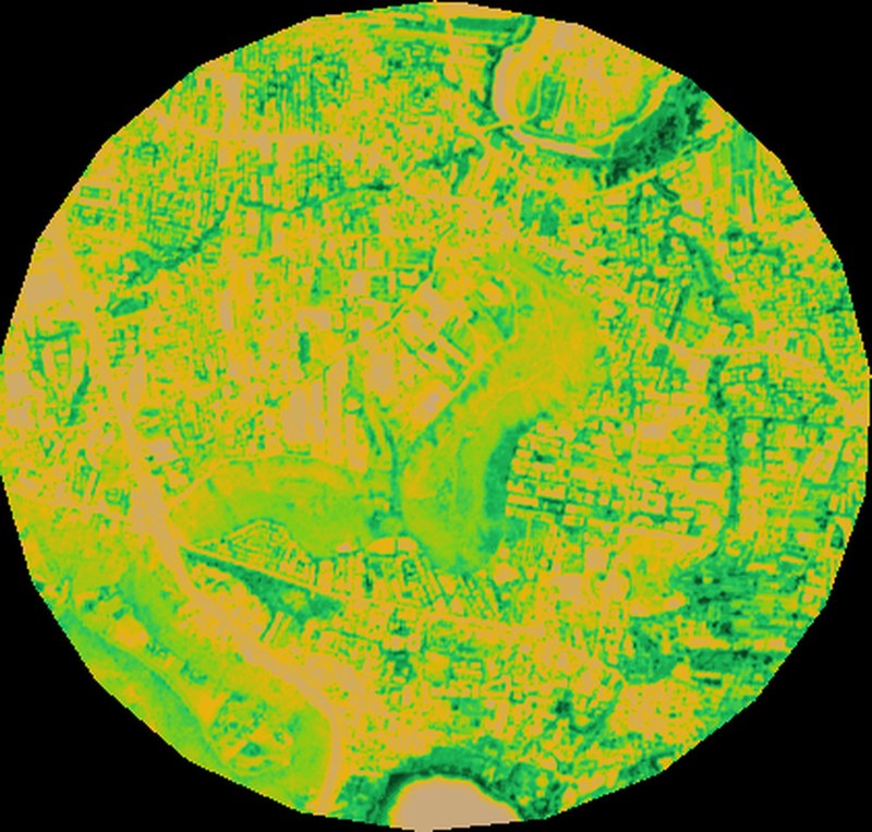
The NDVI heatmap above is not just a scientific image — it is a volunteer deployment map. Every orange and yellow zone is a call to action. These areas have NDVI below 0.25 and have not recovered since 1990. They will not recover without intervention.
🔴 Priority 1 — Plant Immediately
South-West Corridor
0.11 NDVI
Bare laterite. High fire risk. Accessible from the western trail. Recommended: Karvi, Teak, Flame of the Forest. Plant in groups of 7–10 for mutual protection.
🔴 Priority 2 — This Monsoon Season
South-Facing Mid-Slope
0.14 NDVI
Direct solar exposure all day. Loses moisture fastest. Needs drought-tolerant deep-rooters. Recommended: Neem, Pongamia, Bel. Plant in clusters of 5 to create shared shade.
🟡 Priority 3 — Gap-Fill & Support
East Face Trail Corridor
0.38 NDVI
Recovering but patchy. Trail-edge erosion visible. Recommended: Bamboo for slope stabilisation, Hirda, Indian Gooseberry. Check survival of prior plantings.
🟢 Protect — Do Not Disturb
North Slope & Summit
0.67–0.72 NDVI
Dense established canopy. Monsoon peak reaches 0.957 here. This is what the whole hill can become. Protect from encroachment and overgrazing. Focus volunteer energy on south zones.
Best planting window: June 1–15 — before the monsoon peaks, so saplings establish root systems with the first rains. | This map updates annually after the post-monsoon Sentinel-2 pass each November. Zone NDVI values from 2026 dry-season Sentinel-2 composite at 10m resolution.
Data: Landsat-5 C02 T1_L2 (USGS/NASA, 1988–1992 composite), Sentinel-2 SR Harmonized (ESA/Copernicus, Nov 2025–Apr 2026 dry; Jun–Oct 2025 monsoon peak via qualityMosaic). Google Earth Engine. Coordinates: 18.5520°N, 73.7854°E, 1.2km radius. NDVI = (B8−B4)/(B8+B4). Target NDVI 0.55 based on comparable recovered secondary Ghats forest benchmarks. Zone classifications approximate — updated annually post-monsoon. Earth Pulse — earth-pulse.org